Showing posts with label story. Show all posts

Friday, May 20, 2011

Forts Across the American West
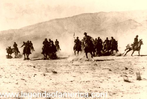
The forts of the American West varied in type from military posts, to fortresses established by fur trading companies, to private enterprises built solely to protect the pioneers within.

Most often when we think of Old West forts, we imagine a high stockade type wall of sharpened logs that surround a number of buildings. Inside these walls are hardy pioneers and soldiers, valiantly defending themselves from hostile Indians on the outside. Though western films have perpetuated this idea, and sometimesforts were built in a stockade type manner, the purpose and style offorts varied widely and this "typical" scenario was the exception rather than the rule.

Contrary to the myths perpetuated by western films, most militaryforts of the American West were not established to protect the settlers from Indians; rather, they were built to maintain peaceamong the tribes, as well as between Native Americans and white emigrants.

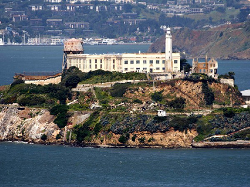
Alcatraz Island
Many people are not aware that Alcatraz was a fort
 before it became a Penitentiary. Photo by
John Sullivan, March, 2005.
This image available for photographic prints
 and downloads HERE!
U.S. CavalryFurthermore, they were seldom solidly constructed stockades with numerous permanent buildings. Sometimes, they were little more than a couple of blockhouses. Other types of fortifications were constructed by traders to protect their businesses and by settlers to protect their homes.
As more and more settlers moved west in the 19th century Army posts were established on the basis of anticipated use, sometimes to keep the Indian tribes from waging war with each other and at other times, to keep white settlers from encroaching upon native lands.
It was generally only when white settlers insisted on encroaching upon native lands, especially during the many gold and silver rushes, that the Indians retaliated. Only then did the forts’ primary purpose change to protecting the settlers. As westward expansion continued, threatening the Indian's livelihood, war between the whites and Indiansintensified, resulting in the push of Native Americans onto reservations. Once the Indianswere placed on reservations, some forts served as Indian agencies and distribution points for annuities given to tribes under treaty agreements.
When the many trails began to open such, as the Santa Fe Trail in the 1820’s and theOregon Trail in the 1840’s, traders and pioneers often met with not only, opposition from the tribes, but also, by road agents interested in relieving them of their money or their goods. In response, more forts were established to protect commerce along the trails.
When establishing a new fort, the soldiers would sometimes occupy buildings already established, but more often, were required to construct the new fort from materials available in the area. In forested areas, wood was usually used; adobe in the desert, and stone, where available. The typical frontier fort consisted of officers' quarters, barracks, stables, storehouses, and headquarters buildings, grouped around a central parade ground. Mostforts did not have walls surrounding them because attacks were generally unlikely.
Many army posts were referred to as "camps,” when there were only a few people assigned to the location or when the site was temporary. To be considered a "fort,” a full contingent of troops had to be permanently assigned to it. Both forts and camps were utilized by the U.S. Army during the Frontier Campaigns.
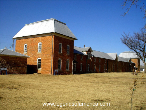
Fort El Reno, Oklahoma Commisary and Weapons Magazine, November,
2005, Kathy Weiser. This image available for photographic prints and
 downloads HERE!

Reacting to the quickly changing needs of the vast west, the Army would set up a post and then abandon it when no longer needed.
Though it was not the original intent to establish militaryforts to fight the Indian Wars, this changed when the U.S. government failed to protect tribal territorial rights and uphold treaties. Increasingly upset with treaty violations and travelers, settlers, and railroad crews encroaching on their lands, the Indians were retaliating in full force by the mid-1800s.
As a result the U.S. Government began a series of frontier campaigns to "tame” the Indians, force them on to reservations, and convert them to "civilized” life.

For the soldier, life was difficult and often monotonous at these many frontier outposts. The vast majority of recruits saw little or no combat and spent their time doing manual labor. Many forts were so isolated there were no nearby towns for single enlisted men to relieve the monotony or meet women. The normal "dull existence” of frontier life was too much for many of the troops and desertion rates were high.

Today, many of these Old West forts have been preserved, restored or rebuilt as monuments to our heritage and can still be seen as museums and national or state parks.


© Kathy Weiser/Legends of America, updated January, 2011.


Also See:


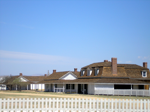
Fort Verde, Arizona

See my great buy's deals4all.yolasite.com

Friday, May 6, 2011

CALIFORNIA LEGENDS Lost Chinese Cache Volcanoville


By Anthony Belli

Forgotten now are the thousand or more places where much of El Dorado County’s history was written. In mining camps and towns such as… Hell Roaring Diggings, Loafer’s Hollow, Whiskey Flat, George’s Town, and Poverty Flat. The names of other camps frequently told you much about who was mining there… Chile Bar (Chileans), Kanakatown (Hawaiians), Frenchtown, Alabama Flat, Texas Bar, Cooley Mine (Chinese), Indian Diggings, Mormon Gulch, even Puritan Camp. Forever consigned to the records of time each of these camps had it’s own unique and often colorful history. One such place is the ghost town of Volcanoville where tales of it’s past includes mining, and buried treasures. 


Volcanoville, California
One of a few remaining abandoned buildings left standing in the ghost town of Volcanoville, photo by Anthony Belli.

It was here during the days of the California Gold Rush when the Volcanoville boasted a lively population of thousands, including a large Chinatown. In the cemetery, two headstones remain which speak of the town’s past. The tombstones tell of two 49ers interred here -- both youths had been murdered for their miner’s poke by Gold Rush highwaymen.

Located in northwest El Dorado County, Volcanoville sits just south of the Middle Fork of the American River. Today telephone poles along Volcanoville Road mark the edge of progress - stopping just short of the old town site where few old buildings stand in defiance of encroaching development.

It was during the mid-1870’s when Volcanoville saw a serious decline in mining as many quartz mines played out. With gold more difficult to find, anger and hate for all non-Anglos in the diggings became a hot subject. Most Chinese were now working in the larger cities in Northern
California, for those who remained in the Mother Lode they suffered the most since they represented competition to White miners. Such was the case in 1874 when Chinese miners discovered a 10 oz. pure gold nugget on their claim at the Cooley (Chinese) Mine in Volcanoville ....

One evening a group of miners gathered at a local saloon where their conversation turned towards the dreaded Chinese. With enough liquor, words quickly turned to action leading to the massacre of at least 15 Chinese that night. The Chinese miners were rounded up by the drunks and herded into a cabin. With the Chinese locked inside, the cabin was set a fire. Those who died in the inferno were only spared a bullet; those who ran from the flames and thick smoke were quickly gunned downed in flight. None survived.

While many Chinese were mining along the Middle Fork of the American River one group of 12 from Volcanoville was buried alive in a cave-in during the 1890’s. By the time aid reached the men they had died from suffocation.

Another story from Volcanoville tells of a wealthy Chinese store owner who ran a thriving general store. He sold out to another China man and himself returned to China. For years he remained in his homeland before returning to Volcanoville.

Chinese miners in Calfiornia, mid 1800's.
Chinese miners in California, mid 1800's.

He claimed he returned to retrieve a cache of gold he’d hidden years earlier. A major fire had destroyed much of the town in 1879 which left the older former store owner with no landmarks to guide him to his treasure. He returned several times over the next several years looking for his lost cache but never found it.

For years treasure hunters have sought to answer the question of the lost Chinese caches buried in and around Volcanoville.

Volcanoville was founded as a small trading post in 1851 but grew into a large prospering Gold Rush town by 1855. Other industry in the area included a steam driven sawmill and tannery at Mt. Gregory. Volcanoville became a voting prescient in 1854 and established it own Post Office in 1858.

 Mining became prosperous here again during the 1880’s and remained so through the 1890’s supporting a twenty-stamp mill. At that time the largest working quartz mine was the Josephine. As most of the town’s residents were employees of the Josephine Mine, in 1895 the Post Office changed the name of the town from Volcanoville to Josephine. The Josephine Post Office operated until discontinued in 1917. The town saw two devastating fires, the first in 1879 then again in 1907. All of the remaining original buildings to survive the 1879 fire were destroyed in the 1907 fire. A small community re-established itself here but the town never recovered.

Somewhere I once read that "25% of all the precious metals and gems ever recovered have become lost". It is true during the era when global transportation was provided by the great sailing ships of the day much treasure went down the result of accident, piracy, or violent storms. The next cause has been laid to natural disasters. Finally the remainder is credited to the individual who acquires wealth and buries it for safekeeping. For whatever reason, the owner of the cache is separated from his wealth and is never able to recover it. It is said that a dozen or more of these buried Chinese caches is connected to the history at Volcanoville.


Hope you enjoyed the story get your hunting supplies here -


Tuesday, March 1, 2011

The California Trail - Rush to Gold
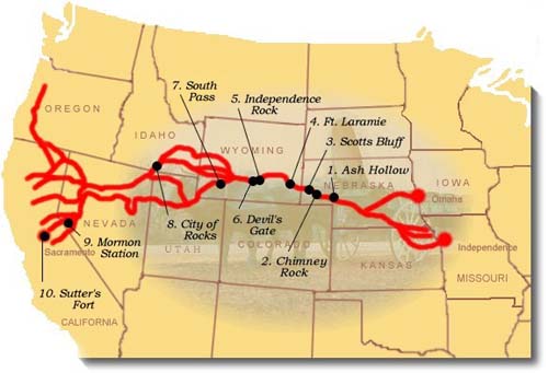

California Trail map
California Trail courtesy National Park Service

"If we never see each other again, do the best you can, God will take care of us."

- Patty Reed of the Donner-Reed Party 1846
The California Trail carried over 250,000 gold-seekers and farmers to the gold fields and rich farmlands of the Golden State during the 1840s and 1850s, the greatest mass migration in American history. The general route began at various jumping off points along the Missouri River and stretched to various points in CaliforniaOregon, and the SierraNevada. The specific route that emigrants and forty-niners used depended on their starting point in Missouri, their final destination in California, the condition of their wagons and livestock, and yearly changes in water and forage along the different routes. The trail passes through the states of MissouriKansasNebraskaColoradoWyomingIdaho,UtahNevadaOregon, and California.

Before the trail was blazed, the Great Basin region had only been partially explored during the days of Spanish and Mexican rule. However, that changed in 1832 when Benjamin Bonneville, a United States Army officer, requested a leave of absence to pursue an expedition to the west. The expedition was financed by John Jacob Astor, a rival of the Hudson Bay company. While Bonneville was exploring the Snake River in Wyoming, he sent a party of men under Joseph Walker to explore the Great Salt Lake and find an overland route to California.
Early settlers began to use the trail in the 1840's, the first of which was John Bidwell, who led the 1841 Bidwell-Bartleson Party. In 1842, a member of the Bidwell-Bartleson Party returned to Missouri on the Humboldt River Route. Among them was a man named Joseph Chiles, who would lead another party to California in 1843 and play an important part in the subsequent opening of more segments of the California Trail. Throughout the 1840's settlers would develop short cuts on the route to California. One such short cut, called the Hastings Route, ran south of the main route. This "new" route would spell the death of many of those in the infamous Donner Party.
Donner Lake Encampment
Lithograph of Donner Party encampment at Donner Lake
 by C.W. Burton, courtesy California Digital Library.

The main branch of the trail across the Great Plains generally followed the same path as the Oregon and Mormon Trails, but extended to California from various points in southern Wyoming and Idaho. The trail followed the Missouri River before crossing the great plains of Nebraska along the Platte and North Platte Rivers to present-day Wyoming. It then followed the Sweetwater River across Wyoming, then northwest along the Snake River to Fort Hall in present-day southeastern Idaho. Fort Hall was the Hudson Bay Company's post on the Snake River. From here, the primary route followed the Snake River south to American Falls, past Massacre Rocks, and Register Rock to cross the Raft River. After the crossing of the river, the trail split with theOregon Trail, with the California bound emigrants turning south through the Raft River Valley to the City of Rocks.The trail then climbed through the Pinnacle and Granite Passes, before dropping down to Goose Creek and meandering south through the northwest corner of Utah and into Nevada. At the headwaters of the Humboldt River in present-day northwesternNevada the California Trail followed the north bank of the Humboldt River southwest through present day Elko, Nevada and the narrow Carlin Canyon, where, during periods of high water, the route was almost impassable.
West of Carlin, the California Trail climbed Emigrant Pass, descending into Emigrant Canyon to rejoin the Humboldt River at Gravelly Ford. Here, the route divided to follow the north and south sides of the river, before rejoining at Humboldt Bar. Various routes branched out across the Sierra Nevada, as the emigrants made there way to various destinations in California.

Early emigrants once called the California Trail an elephant, due to the difficult journey. If you wanted to get to California in pre-railroad times, you were guaranteed an arduous trek. California emigrants faced the greatest challenges of all the pioneer emigrants of the mid-19th century. In addition to the Rockies, these emigrants faced the barren deserts of Nevada and the imposing SierraNevada Range.

The travelers of the California Trail often quipped that if you had "seen the elephant," then you had hit some hard traveling.

When gold was discovered at Sutter's Mill in Coloma, California, the trickle of emigrants became a flood as thousands of prospectors and families made their way to the Golden State in hopes of finding their fortunes. According to some statistics, over 70,000 emigrants used the California Trail in 1849 and 1850 alone.

In the two decades of the 1840's and 1850's, the California Trailcarried over 250,000 gold-seekers and farmers to the state's gold fields and rich farmlands. It was the greatest mass migration in American history.

Eventually, the portions of the railroad followed parts of the California Trail and as the automobile was introduced and began to be used by the masses, highways replaced the trail. Today, U.S. Highways 40 and 80 follow the path of the California Trail.

The California Trail system, which now includes approximately 5,665 miles of trails, was developed over a period of years. Numerous cutoffs and alternate routes were tried along theCalifornia Trail to see which was the "best" in terms of terrain, length and sufficient water and grass for livestock.

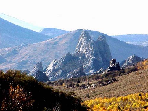
City of Rock in southern Idaho
City of Rocks in southern Idaho courtesy
National Park Service


California Trail in Nevada, approaching the Sierra Nevada
California Trail in Nevada, approaching the Sierra
Nevada, courtesy National Park Service.


Today, more than 1,000 miles of trail ruts and traces can still be seen in the vast undeveloped lands between Casper, Wyoming and the West Coast, reminders of the sacrifices, struggles, and triumphs of early American travelers and settlers. About 2,171 miles of this system cross public lands, where most of the physical evidence that still exists today is located, including the names of emigrants written with axle grease on the rocks at theCity of Rocks National Reserve in southern IdahoMore than 300 historic sites along the trail will eventually be available for public use and interpretation.
© Kathy Weiser/Legends of America, updated June, 2010.

Wednesday, February 9, 2011

The California Trail - Rush to Gold


California Trail map
California Trail courtesy National Park Service

"If we never see each other again, do the best you can, God will take care of us." 

- Patty Reed of the Donner-Reed Party 1846


The California Trail carried over 250,000 gold-seekers and farmers to the gold fields and rich farmlands of the Golden State during the 1840s and 1850s, the greatest mass migration in American history. The general route began at various jumping off points along the Missouri River and stretched to various points in California, Oregon, and the SierraNevada. The specific route that emigrants and forty-niners used depended on their starting point in Missouri, their final destination in California, the condition of their wagons and livestock, and yearly changes in water and forage along the different routes. The trail passes through the states of Missouri, Kansas, Nebraska, Colorado, Wyoming, Idaho,Utah, Nevada, Oregon, and California.

Before the trail was blazed, the Great Basin region had only been partially explored during the days of Spanish and Mexican rule. However, that changed in 1832 when Benjamin Bonneville, a United States Army officer, requested a leave of absence to pursue an expedition to the west. The expedition was financed by John Jacob Astor, a rival of the Hudson Bay company. While Bonneville was exploring the Snake River in Wyoming, he sent a party of men under Joseph Walker to explore the Great Salt Lake and find an overland route to California.
Early settlers began to use the trail in the 1840's, the first of which was John Bidwell, who led the 1841 Bidwell-Bartleson Party. In 1842, a member of the Bidwell-Bartleson Party returned to Missouri on the Humboldt River Route. Among them was a man named Joseph Chiles, who would lead another party to California in 1843 and play an important part in the subsequent opening of more segments of the California Trail. Throughout the 1840's settlers would develop short cuts on the route to California. One such short cut, called the Hastings Route, ran south of the main route. This "new" route would spell the death of many of those in the infamous Donner Party.
Donner Lake Encampment
Lithograph of Donner Party encampment at Donner Lake
 by C.W. Burton, courtesy California Digital Library.

The main branch of the trail across the Great Plains generally followed the same path as the Oregon and Mormon Trails, but extended to California from various points in southern Wyoming and Idaho. The trail followed the Missouri River before crossing the great plains of Nebraska along the Platte and North Platte Rivers to present-day Wyoming. It then followed the Sweetwater River across Wyoming, then northwest along the Snake River to Fort Hall in present-day southeastern Idaho. Fort Hall was the Hudson Bay Company's post on the Snake River. From here, the primary route followed the Snake River south to American Falls, past Massacre Rocks, and Register Rock to cross the Raft River. After the crossing of the river, the trail split with theOregon Trail, with the California bound emigrants turning south through the Raft River Valley to the City of Rocks.The trail then climbed through the Pinnacle and Granite Passes, before dropping down to Goose Creek and meandering south through the northwest corner of Utah and into Nevada. At the headwaters of the Humboldt River in present-day northwesternNevada the California Trail followed the north bank of the Humboldt River southwest through present day Elko, Nevada and the narrow Carlin Canyon, where, during periods of high water, the route was almost impassable.
West of Carlin, the California Trail climbed Emigrant Pass, descending into Emigrant Canyon to rejoin the Humboldt River at Gravelly Ford. Here, the route divided to follow the north and south sides of the river, before rejoining at Humboldt Bar. Various routes branched out across the Sierra Nevada, as the emigrants made there way to various destinations in California.

Early emigrants once called the California Trail an elephant, due to the difficult journey. If you wanted to get to California in pre-railroad times, you were guaranteed an arduous trek. California emigrants faced the greatest challenges of all the pioneer emigrants of the mid-19th century. In addition to the Rockies, these emigrants faced the barren deserts of Nevada and the imposing SierraNevada Range.


"I think that I may without vanity affirm
that I have seen the elephant."

- Louisa Clapp

The travelers of the California Trail often quipped that if you had "seen the elephant," then you had hit some hard traveling.

When gold was discovered at Sutter's Mill in Coloma, California, the trickle of emigrants became a flood as thousands of prospectors and families made their way to the Golden State in hopes of finding their fortunes. According to some statistics, over 70,000 emigrants used the California Trail in 1849 and 1850 alone.

In the two decades of the 1840's and 1850's, the California Trailcarried over 250,000 gold-seekers and farmers to the state's gold fields and rich farmlands. It was the greatest mass migration in American history.

Eventually, the portions of the railroad followed parts of the California Trail and as the automobile was introduced and began to be used by the masses, highways replaced the trail. Today, U.S. Highways 40 and 80 follow the path of the California Trail.

The California Trail system, which now includes approximately 5,665 miles of trails, was developed over a period of years. Numerous cutoffs and alternate routes were tried along theCalifornia Trail to see which was the "best" in terms of terrain, length and sufficient water and grass for livestock.

City of Rock in southern Idaho
City of Rocks in southern Idaho courtesy
National Park Service


California Trail in Nevada, approaching the Sierra Nevada
California Trail in Nevada, approaching the Sierra
Nevada, courtesy National Park Service.


Time to get your spring season equipment try looking at 
Today, more than 1,000 miles of trail ruts and traces can still be seen in the vast undeveloped lands between Casper, Wyoming and the West Coast, reminders of the sacrifices, struggles, and triumphs of early American travelers and settlers. About 2,171 miles of this system cross public lands, where most of the physical evidence that still exists today is located, including the names of emigrants written with axle grease on the rocks at theCity of Rocks National Reserve in southern Idaho. More than 300 historic sites along the trail will eventually be available for public use and interpretation.
© Kathy Weiser/Legends of America, updated June, 2010.

Friday, February 4, 2011

The Sand Creek Massacre Great Places for metal detectors!!!

Sand Creek Massacre


Painting of the attack on Sand Creek, courtesy the Colorado Historical Society


The Sand Creek Massacre, occurring on November 29, 1864, was one of the most infamous incidents of the Indian Wars. Initially reported in the press as a victory against a bravely fought defense by the Cheyenne, later eyewitness testimony conflicted with these reports, resulting in a military and two Congressional investigations into the events.
Starting in the 1850’s, the gold and silver rush in the Rocky Mountains brought thousands of white settlers into the mountains and the surrounding foothills. Dislocating and angering the Cheyennes and Arapahos who lived on the land, the Pike's Peak Gold Rush in 1858 brought the tension to a boiling point.

Washington, December 20, 1864

"The affair at Fort Lyon, Colorado, in which Colonel Chivington destroyed a large Indian village, and all its inhabitants, is to be made the subject of congressional investigation. Letters received from high officals in Colorado say that the Indians were killed after surrendering, and that a large proportion of them were women and children."
The Indians soon began to attack wagon trains, mining camps and stagecoach lines, a practice that increased during the Civil War, when the number of soldiers in the area was greatly decreased. Soon, this led to what became known as the Colorado War of 1864-1865.
As the violence between the Native Americans and the miners continued to increase, territorial governor John Evans sent a Voluntary Militia commander by the name of Colonel John Chivington to quiet the Indians. Chivington, though once a member of the clergy, his compassion did not extend to the Indians and his desires to extinguish them all was well known.
In the spring of 1864, while the Civil War raged in the east, Chivington launched a campaign of violence against the Cheyenne and their allies, his troops attacking any and all Indiansand razing their villages. The Cheyenne, joined by neighboring ArapahoSiouxComanche, and Kiowa in both Colorado and Kansas, went on the defensive warpath.
Soon, Evans and Chivington reinforced their militia, raising the Third Colorado Cavalry of short-term volunteers who referred to themselves as the "Hundred Dazers." After a summer of scattered small raids and clashes, the Cheyennes and Arapahos were ready for peace, and as a result, the Indian representatives met with Evans and Chivington at Camp Weld outside of Denver on September 28, 1864. Though no treaties were signed, the Indiansbelieved that by reporting and camping near army posts, they would be declaring peace and accepting sanctuary. 
However on the day of the "peace talks” Chivington received a telegram from General Samuel Curtis (his superior officer) informing him that "I want no peace till the Indians suffer more...No peace must be made without my directions."
Unaware of Curtis's telegram, Black Kettle and some 550 Cheyennes and Arapahos, having made their peace, traveled south to set up camp on Sand Creek under the promised protection of Fort Lyon. Those who remained opposed to the agreement headed North to join the Sioux.
Knowing that the Indians had surrendered, Chivington led his 700 troops, many of them drinking heavily, to Sand Creek and positioned them, along with their four howitzers, around the Indian village. The ever trusting Black Kettle raised both an American and a white flag of peace over his tepee.

However, Chivington ignored the symbol of peace and surrender, raising his arm for attack. An easy victory at hand, cannons and rifles began to pound upon the camp as the Indians scattered in panic. The frenzied soldiers began to charge, hunting down men, women, and children, shooting them unmercifully. A few warriors managed to fight back allowing some members of the camp to escape across the stream.
One man, Silas Soule, a Massachusetts abolitionist, refused to follow Colonel Chivington's orders. He did not allow his cavalry company to fire into the crowd.
The troops kept up their indiscriminate assault for most of the day, during which numerous atrocities were committed. One lieutenant was said to have killed and scalped three women and five children who had surrendered and were screaming for mercy. Finally breaking off their attack they returned to the camp killing all the wounded they could find before mutilating and scalping the dead, including pregnant women, children and babies. They then plundered the teepees and divided up theIndians' horse herd before leaving
When the attack was over, as many as 150 Indians lay dead, most of which were old men, women and children. In the meantime, the cavalry lost only 9 or ten men, with about three dozen wounded. Black Kettle and his wife followed the others up the stream bed, his wife being shot in the back and left for dead.
Black Kettle's wife, although shot nine times, somehow managed to survived the attack. The survivors, over half of whom were wounded, sought refuge in the camp of the Cheyenne Dog Warriors (who had remained opposed to the peace treaty) at Smokey Hill River. Many of the Indians joined the Dog Soldiers, deciding there could be no successful negotiations with the white men and were waging war against them. Indeed, the Sand Creek Massacre is cited as a critical cause of the Little Big Horn battle, as many Cheyenne warriors simply devoted their lives to war against the US.
The Colorado volunteers returned to Denver, exhibiting their scalps, to receive a hero's welcome. Initially the battle was reported in the press as a victory against a bravely-fought defense by the Cheyenne. Within weeks, however, eyewitnesses came forward offering conflicting testimony, leading to a military investigation and two Congressional investigations into the events. Silas Soule was eager to testify against Chivington. However, after he testified, Soule was murdered by Charles W. Squires, believed to have been ordered by Chivington.
As the details came out, the US public was shocked by the brutality of the massacre. The congressional investigation subsequently determined the crime to be a "sedulously and carefully planed massacre." When asked at the military inquiry why children had been killed, one of the soldiers quoted Chivington as saying, "nits make lice." Though Chivington was denounced in the investigation and forced to resign, neither he nor anyone else was ever brought to justice for the massacre.
While the Sand Creek Massacre outraged easterners, it seemed to please many people in Colorado Territory. Chivington later appeared on a Denver stage where he regaled delighted audiences with his war stories and displayed 100 Indian scalps, including the pubic hairs of women.
As word of the massacre spread among the Indians of the southern and northern plains, their resolve to resist white encroachment stiffened. An avenging wildfire swept the land and peace returned only after a quarter of a century.
Through the years, the area of the Sand Creek Massacre has continued to be visited and commemorated. An aging John Chivington returned to the area in 1887, and in 1908 Veterans of the Colorado Regiments planned a reunion at the site. In August of 1950 the Colorado Historical Society assisted local residents and the Eads and Lamar Chambers of Commerce in placing a marker atop the bluff at the Dawson South Bend. Sand Creek descendants remain active in tribal communities inMontanaOklahoma, and Wyoming – and Council Representatives continue to work alongside the National Park Service.  
The massacre site was authorized as a National Historic site on August, 2, 2005. However, it will not be established until theNational Park Service acquires enough land to provide for the preservation, commemoration, and interpretation of the Sand Creek Massacre and is not yet open to the public.

© Kathy Weiser/Legends of America, updated August, 2010.

Contact Information:
P.O. Box 249
Eads, 
Colorado 81036 
719-438-5916


Legends of America Lodging
Book your lodging right HERE online


Camp Weld meeting
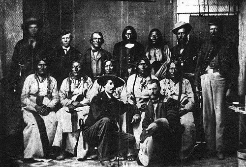
Black Kettle (seated center) and other Cheyenne chiefs conclude successful peace talks with Major Edward W. Wynkoop (kneeling with hat) at Fort Weld, Colorado, in September 1864. Based on the promises made at this meeting, Black Kettle led his band back to the Sand Creek reservation, where they were massacred in late November. Photo courtesy National Archives.

Native American Vintage PhotographsNative American Photo Prints  - Vintage photographs of famous chiefs, heroes, and Indian life in the 19th century.


Hope You Enjoyed The Story !
Please take a look at these other websites Gold Seekers Tools And Prospectors Tools

Cute video watch it !

GoAnimate.com: wealth 4 all dinner by mrhall909

Like it? Create your own at GoAnimate.com. It's free and fun!