Showing posts with label photo. Show all posts

Friday, May 20, 2011

Forts Across the American West

The forts of the American West varied in type from military posts, to fortresses established by fur trading companies, to private enterprises built solely to protect the pioneers within.

Most often when we think of Old West forts, we imagine a high stockade type wall of sharpened logs that surround a number of buildings. Inside these walls are hardy pioneers and soldiers, valiantly defending themselves from hostile Indians on the outside. Though western films have perpetuated this idea, and sometimesforts were built in a stockade type manner, the purpose and style offorts varied widely and this "typical" scenario was the exception rather than the rule.

Contrary to the myths perpetuated by western films, most militaryforts of the American West were not established to protect the settlers from Indians; rather, they were built to maintain peaceamong the tribes, as well as between Native Americans and white emigrants.

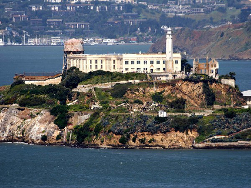
Alcatraz Island
Many people are not aware that Alcatraz was a fort
 before it became a Penitentiary. Photo by
John Sullivan, March, 2005.
This image available for photographic prints
 and downloads HERE!
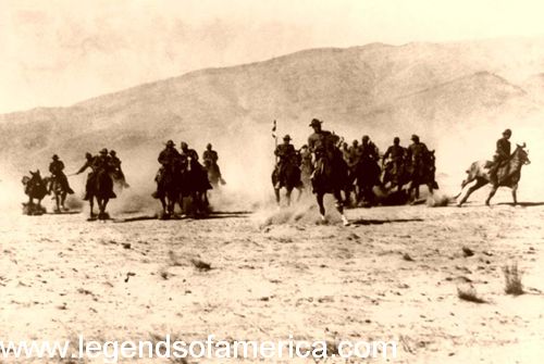
U.S. CavalryFurthermore, they were seldom solidly constructed stockades with numerous permanent buildings. Sometimes, they were little more than a couple of blockhouses. Other types of fortifications were constructed by traders to protect their businesses and by settlers to protect their homes.
As more and more settlers moved west in the 19th century Army posts were established on the basis of anticipated use, sometimes to keep the Indian tribes from waging war with each other and at other times, to keep white settlers from encroaching upon native lands.
It was generally only when white settlers insisted on encroaching upon native lands, especially during the many gold and silver rushes, that the Indians retaliated. Only then did the forts’ primary purpose change to protecting the settlers. As westward expansion continued, threatening the Indian's livelihood, war between the whites and Indiansintensified, resulting in the push of Native Americans onto reservations. Once the Indianswere placed on reservations, some forts served as Indian agencies and distribution points for annuities given to tribes under treaty agreements.
When the many trails began to open such, as the Santa Fe Trail in the 1820’s and theOregon Trail in the 1840’s, traders and pioneers often met with not only, opposition from the tribes, but also, by road agents interested in relieving them of their money or their goods. In response, more forts were established to protect commerce along the trails.
When establishing a new fort, the soldiers would sometimes occupy buildings already established, but more often, were required to construct the new fort from materials available in the area. In forested areas, wood was usually used; adobe in the desert, and stone, where available. The typical frontier fort consisted of officers' quarters, barracks, stables, storehouses, and headquarters buildings, grouped around a central parade ground. Mostforts did not have walls surrounding them because attacks were generally unlikely.
Many army posts were referred to as "camps,” when there were only a few people assigned to the location or when the site was temporary. To be considered a "fort,” a full contingent of troops had to be permanently assigned to it. Both forts and camps were utilized by the U.S. Army during the Frontier Campaigns.
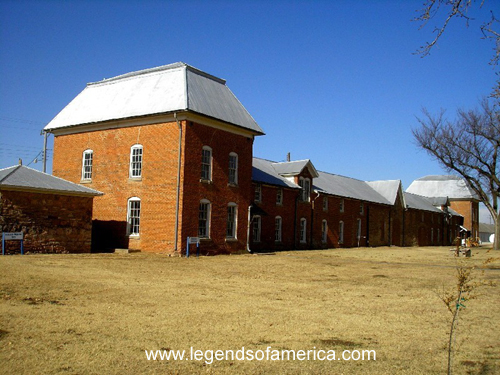
Fort El Reno, Oklahoma Commisary and Weapons Magazine, November,
2005, Kathy Weiser. This image available for photographic prints and
 downloads HERE!

Reacting to the quickly changing needs of the vast west, the Army would set up a post and then abandon it when no longer needed.
Though it was not the original intent to establish militaryforts to fight the Indian Wars, this changed when the U.S. government failed to protect tribal territorial rights and uphold treaties. Increasingly upset with treaty violations and travelers, settlers, and railroad crews encroaching on their lands, the Indians were retaliating in full force by the mid-1800s.
As a result the U.S. Government began a series of frontier campaigns to "tame” the Indians, force them on to reservations, and convert them to "civilized” life.

For the soldier, life was difficult and often monotonous at these many frontier outposts. The vast majority of recruits saw little or no combat and spent their time doing manual labor. Many forts were so isolated there were no nearby towns for single enlisted men to relieve the monotony or meet women. The normal "dull existence” of frontier life was too much for many of the troops and desertion rates were high.

Today, many of these Old West forts have been preserved, restored or rebuilt as monuments to our heritage and can still be seen as museums and national or state parks.


© Kathy Weiser/Legends of America, updated January, 2011.


Also See:


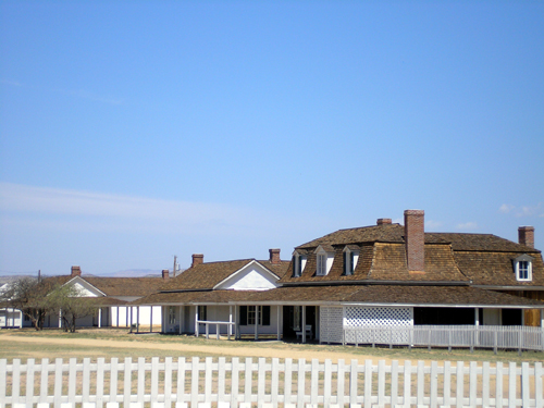
Fort Verde, Arizona

See my great buy's deals4all.yolasite.com

Sunday, April 3, 2011

IDAHO LEGENDS Battle of Pierre's Hole


By Hiram Martin Chittenden, 1902

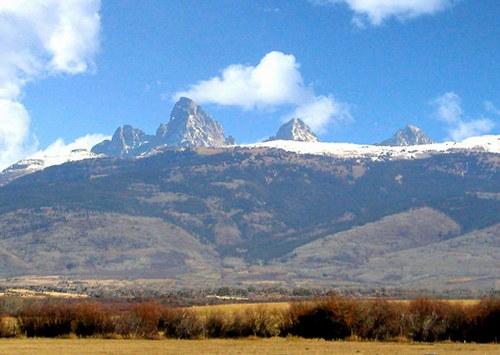
Pierre's Hole, as it was then called, or Teton Basin, its present name, is one of those valleys which are veritable oasis in the desert of rugged mountains. Very few of these valleys exceed that of Pierre's Hole in beauty. It is overhung on the east by that noble range of mountains whose culminating peak is the Grand Teton. The valley extends in a direction from southeast to northwest. It is fully thirty miles long and from five to fifteen miles wide. It appears like a broad, flat prairie almost destitute of trees except along its principal river and the various tributaries.

These typical mountain streams descend mostly from the Teton range, where they are fed by perennial snows and almost daily summer rains.

Pierre's Hole, Idaho
Pierre's Hole, Idaho, photo courtesy The Fur Trapper.com

The course of these streams can be traced for great distances by the ribbons of lush greenery which cross the plain here and there and unite with a larger line of trees along the central stream. These forests are more extensive than the observer from a distance would imagine. The more considerable cottonwood groves are often so filled with tangled growths of willows and creeping vines as to be almost impenetrable, and in many places it is a physical impossibility to get through them until the brush has been cut away. In the summer of 1832 the Rocky Mountain and American Fur Companies had their rendezvous in the upper part of the valley of Pierre's Hole some twelve or fifteen miles from Teton Pass. With their accustomed alacrity of movement, the managers of the RockyRocky Mountain Fur Company had excelled their rivals in reaching the rendezvous with their annual supplies. William L. Sublette arrived there with a party of about sixty men on July 6th. Nathaniel Wyeth was with him and so were the remnants of Jefferson Blackwell's and John Gannt's parties of the previous year whom Sublette had found on the Laramie River. Vanderburgh and Drips, of the American Fur Company, were also present. Lucien Fontenelle, who was coming from Fort UnionNorth Dakotawith supplies, was still far behind in the Bighorn Valley. Captain Benjamin Bonneville, likewise headed in the same direction, was still in the valley of the Platte River. In the valley of Pierre's Hole were also many hundreds of Indians, mostly of the Salish andNez PercĂ© tribes. The Gros Ventre, ever hostile to the whites, were this year particularly troublesome around the headwaters of the Snake and Green Rivers. Although a post had been built in the Blackfoot country scarcely a year before -- Fort PieganMontana at the mouth of the Marias River -- this fact seems not at all to have tempered the ferocity of the tribe. They were at this time returning home from a visit to their kindred, the Arapaho.Sublette had had a sharp brush with them on the way to the rendezvous, and Thomas Fitzpatrick, who had gone on ahead, was unhorsed and forced to hide  in the mountains, and wandered for five days without food, reaching the rendezvous more dead than alive.
When the business of the rendezvous was nearly completed, a party of trappers under Milton G. Sublette set out on July 17th, in the direction of the main Snake River toward the southeast. Nathaniel Wyeth embraced this opportunity to secure a good escort out of theBlackfoot country for the remnant of his party who had decided to continue on to the Pacific Coast. The joint party proceeded just a short distance, six or eight miles, and encamped for the night. Just as they were setting out the next morning they discovered a party of horsemen approaching.
They were in doubt for a time whether it was white or Indian, but they soon found that it was a band of Gros Ventre. They were approaching in two parties, and numbered about a 150 men. According to Zenus Leonard, they carried a British flag which they had captured from a party of Hudson Bay trappers, whom they had recently defeated. The Indians came down into the valley with such fierceness that the trappers could not, at first, tell whether they were buffalo, white men or Indians. Finally, by the aid of Wyeth's looking glass, they discovered that there were also Blackfoot Indians, and Milton Sublette at once sent two men to the rendezvous for assistance.
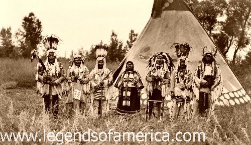
Blackfoot Indians, 1913
This image available for photographic prints  and downloads HERE!

In the meantime, a tragedy of revenge had been enacting on the plain. The Blackfoot, discovering that the force before them was larger than they had supposed, made signs of peace, displaying, it is said, a white flag.

But, such was their general reputation for disloyalty that no confidence was placed in their friendly advances. There were, moreover, in the white camp two men who cherished inextinguishable hatred toward the Blackfoot. One of these was Antoine Godin, whose father had been murdered by theseIndians on Godin Creek. The other was a Salish chief whose nation had suffered untold wrongs from the tribe. When these two men advanced to meet the overtures of peace, a Blackfootchief came forward to meet them. By a previous arrangement made between Godin and the Salish chief, the latter shot theBlackfoot dead at the instant when Godin grasped his hand in friendship. Seizing the chief's scarlet robe, Godin and his companion beat a hasty, though safe, retreat.

The Indians then withdrew into some timber nearby, surrounded by a copse of willows, and immediately entrenched themselves by digging holes in the ground, and building a breastwork of timber in front of their rifle pits. This work was mostly done by the women, the Indians maintaining a skirmish line in front of the fort. While some of the men had gone to the rendezvous for reinforcements, Milton Sublette's trappers held the Indians within the woods, and Wyeth fortified his own camp, where he ordered his men to remain.
William L. Sublette and Robert Campbell, upon receiving the news of attack, immediately left the rendezvous and in short order, arrived on the field with a large force of whites and Indians.
Sublette assumed direction of the battle. He forbade bothWyeth's men and his own raw recruits to engage in the fight, and used only the seasoned trappers and the IndiansWyethhimself, however, was present in the engagement, part of the time. The Blackfoot, when they saw the overwhelming force with which they had to reckon, withdrew within their entrenchments.

The whites and allied Indians promptly commenced the attack by random firing into the thicket. This accomplished nothing, but gave the Blackfoot a chance to do some effective work in return. It was apparent that other measures would have to be adopted to dislodge them, and William L. Sublette proposed to storm the breastworks.  


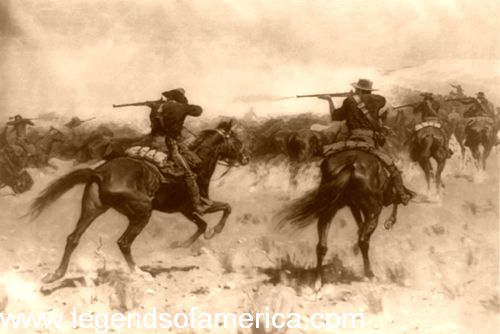
Indian Fighters
Indian Fighters, Frederic Remington, 1907.

His men thought it too dangerous, but Subletteinsisted. About thirty of the whites and as manyIndians joined him, and together they entered the willow thickets. Pushing their way cautiously through the tangled shrubs, Sublette, Campbell, and Alexander Sinclair of Arkansas led the others toward the Indian "fort." Sublette and Campbell and doubtless others had made their wills to each other in anticipation of the consequences that might ensue. After working their way on hands and knees through the dense line of willows they came to more open ground, and then saw the rude fortification of the Indians. As they emerged into this open space they were more exposed to the fire of the BlackfootSinclair was killed on the spot andSublette was severely wounded. In the meantime,Wyeth with some Indians had gained nearly the opposite side of the fort, and one Indian near him was killed by a chance shot from Sublette's party. The besieged Indians suffered little at this time, for they were well protected, although completely overmatched in numbers.
The attack continued for the greater part of the day without any substantial progress, owing to the secure position of the enemy and the evident reluctance of the attackers to storm it. Finally, Sublette decided to burn them out, although much against the wishes of the friendlyIndians, who wanted to plunder the fort. A train of wood was laid and was about to be ignited, when an incident occurred which brought immediate relief to the beleaguered garrison. One of the friendly Indians, who understood the Blackfoot language held some conversation with the besieged during the fight. They now told him that they knew that the whites could kill them, but that they had 600-800 warriors who would soon arrive and who would give them all the fighting they wanted. In the process of interpretation, the Blackfootwas made to say that this force was then actually attacking the main rendezvous.
Such an attack would have been disastrous in the absence of the fighting force, and the whites, without waiting to verify the news, quickly hurried off to the rendezvous site. Before the mistake was discovered, it was too late to resume the attack. On the following morning the Blackfoot fort was found abandoned.
The casualties in this fight were, on the side of the whites were five killed, includingAlexander Sinclair, and six wounded, of whom William L. Sublette was one. The alliedIndians lost seven killed and six wounded. The loss of the Blackfoot was never fully known. They left nine dead warriors in the fort together with 25 horses and nearly all their baggage. Later, it was said that the Blackfoot admitted to having lost 26 warriors.
The Battle of Pierre's Hole was not without its important sequels. On July 25th, seven men of Wyeth's party, together with Alfred K. Stephens and four men, the joint party including a Mr. More of Boston, a Mr. Foy of Mississippi, and two grandsons of Daniel Boone, set out from the rendezvous to return East. They had intended to accompany William L. Sublette, but the latter's departure had been postponed about ten days on account of his wound. Impatient of the delay, these men set out to the eastward, and on the following day, were attacked in Jackson Hole by a band of some twenty Blackfoot. More and Foy were killed and Stephens was wounded. He, with the rest of the party, returned to the rendezvous, where he lingered until July 30th, when he died just after starting for St. Louis in company with William L. Sublette. His horses and traps were sold the same day, and his beaver fur was taken to St. Louis.
Sublette with his party of about 60 men and the furs they had collected over the past year left the  rendezvous on July 30th. The day after crossing the Snake River, on August 4th, they passed the large band of Blackfoot of whom they had been told by the Indian at the Battle of Pierre's Hole. These Indians had been hovering in the vicinity of the camps of Lucien Fontenelle and Benjamin Bonneville, but had not ventured to attack. In like manner, their recent experience in Pierre's Hole made them hesitate about attacking Sublette's party, and he was suffered to pass unmolested. This band of Indians finally left the country by the way of the Wind River Valley, where they were attacked and routed by some Crow Indians with a loss of 40 killed. The remainder were scattered like fugitives throughout the Crow country. It will be remembered that it was Antoine Godin who killed the Blackfoot chief at Pierre's Hole in revenge for the death of his father. But the account was not yet considered closed -- at least on the part of the Blackfoot. At some time between September, 1834 and September, 1835, the exact date unknown, a party of Blackfoot appeared on the opposite bank of the Snake River from Fort Hall. They were led by a desperado named James Bird, a former employee of the Hudson's Bay Company, who, having been made a prisoner by the Blackfoot, in a skirmish with some of that tribe, had remained with them and had become an influential chieftain. From the opposite side of the Snake River, Bird requested Godin to come across and buy their furs. Godin complied, not suspecting treachery. He sat down to smoke with the company, when Bird signaled to some Indians, who shot him in the back. While he was yet alive, Bird tore his scalp off and cut the letters " N.J.W.," Wyeth'sinitials, on his forehead. Thus ended the tragedy of Pierre's Hole.  
Compiled and edited by Kathy Weiser/Legends of America,January, 2010.


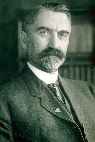
About the Author:  The Battle of Pierre's Hole written by Hiram Martin Chittenden and included in his book, The American Fur trade of the Far West, published in 1902. Chittenden served in the Corps of Engineers, eventually reaching the rank of Brigadier General. During this time, he was in charge of many notable projects including work at the Yellowstone and Yosemite National Parks,  and the Lake Washington Canal Project. He was also an author, penning historical volumes, tour guides, and poetry.

The story, as it appears here, is not verbatim as it has been edited for clarity and ease of the modern reader.
Hiram Martin Chittenden
Hiram Martin Chittenden (1858-1917)


Tuesday, March 1, 2011

The California Trail - Rush to Gold


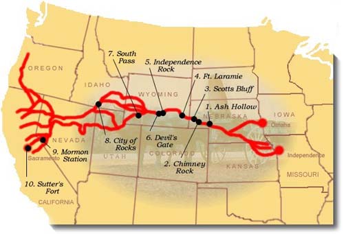
California Trail map
California Trail courtesy National Park Service

"If we never see each other again, do the best you can, God will take care of us."

- Patty Reed of the Donner-Reed Party 1846
The California Trail carried over 250,000 gold-seekers and farmers to the gold fields and rich farmlands of the Golden State during the 1840s and 1850s, the greatest mass migration in American history. The general route began at various jumping off points along the Missouri River and stretched to various points in CaliforniaOregon, and the SierraNevada. The specific route that emigrants and forty-niners used depended on their starting point in Missouri, their final destination in California, the condition of their wagons and livestock, and yearly changes in water and forage along the different routes. The trail passes through the states of MissouriKansasNebraskaColoradoWyomingIdaho,UtahNevadaOregon, and California.

Before the trail was blazed, the Great Basin region had only been partially explored during the days of Spanish and Mexican rule. However, that changed in 1832 when Benjamin Bonneville, a United States Army officer, requested a leave of absence to pursue an expedition to the west. The expedition was financed by John Jacob Astor, a rival of the Hudson Bay company. While Bonneville was exploring the Snake River in Wyoming, he sent a party of men under Joseph Walker to explore the Great Salt Lake and find an overland route to California.
Early settlers began to use the trail in the 1840's, the first of which was John Bidwell, who led the 1841 Bidwell-Bartleson Party. In 1842, a member of the Bidwell-Bartleson Party returned to Missouri on the Humboldt River Route. Among them was a man named Joseph Chiles, who would lead another party to California in 1843 and play an important part in the subsequent opening of more segments of the California Trail. Throughout the 1840's settlers would develop short cuts on the route to California. One such short cut, called the Hastings Route, ran south of the main route. This "new" route would spell the death of many of those in the infamous Donner Party.
Donner Lake Encampment
Lithograph of Donner Party encampment at Donner Lake
 by C.W. Burton, courtesy California Digital Library.

The main branch of the trail across the Great Plains generally followed the same path as the Oregon and Mormon Trails, but extended to California from various points in southern Wyoming and Idaho. The trail followed the Missouri River before crossing the great plains of Nebraska along the Platte and North Platte Rivers to present-day Wyoming. It then followed the Sweetwater River across Wyoming, then northwest along the Snake River to Fort Hall in present-day southeastern Idaho. Fort Hall was the Hudson Bay Company's post on the Snake River. From here, the primary route followed the Snake River south to American Falls, past Massacre Rocks, and Register Rock to cross the Raft River. After the crossing of the river, the trail split with theOregon Trail, with the California bound emigrants turning south through the Raft River Valley to the City of Rocks.The trail then climbed through the Pinnacle and Granite Passes, before dropping down to Goose Creek and meandering south through the northwest corner of Utah and into Nevada. At the headwaters of the Humboldt River in present-day northwesternNevada the California Trail followed the north bank of the Humboldt River southwest through present day Elko, Nevada and the narrow Carlin Canyon, where, during periods of high water, the route was almost impassable.
West of Carlin, the California Trail climbed Emigrant Pass, descending into Emigrant Canyon to rejoin the Humboldt River at Gravelly Ford. Here, the route divided to follow the north and south sides of the river, before rejoining at Humboldt Bar. Various routes branched out across the Sierra Nevada, as the emigrants made there way to various destinations in California.

Early emigrants once called the California Trail an elephant, due to the difficult journey. If you wanted to get to California in pre-railroad times, you were guaranteed an arduous trek. California emigrants faced the greatest challenges of all the pioneer emigrants of the mid-19th century. In addition to the Rockies, these emigrants faced the barren deserts of Nevada and the imposing SierraNevada Range.

The travelers of the California Trail often quipped that if you had "seen the elephant," then you had hit some hard traveling.

When gold was discovered at Sutter's Mill in Coloma, California, the trickle of emigrants became a flood as thousands of prospectors and families made their way to the Golden State in hopes of finding their fortunes. According to some statistics, over 70,000 emigrants used the California Trail in 1849 and 1850 alone.

In the two decades of the 1840's and 1850's, the California Trailcarried over 250,000 gold-seekers and farmers to the state's gold fields and rich farmlands. It was the greatest mass migration in American history.

Eventually, the portions of the railroad followed parts of the California Trail and as the automobile was introduced and began to be used by the masses, highways replaced the trail. Today, U.S. Highways 40 and 80 follow the path of the California Trail.

The California Trail system, which now includes approximately 5,665 miles of trails, was developed over a period of years. Numerous cutoffs and alternate routes were tried along theCalifornia Trail to see which was the "best" in terms of terrain, length and sufficient water and grass for livestock.

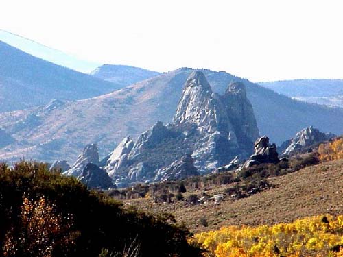
City of Rock in southern Idaho
City of Rocks in southern Idaho courtesy
National Park Service


California Trail in Nevada, approaching the Sierra Nevada
California Trail in Nevada, approaching the Sierra
Nevada, courtesy National Park Service.


Today, more than 1,000 miles of trail ruts and traces can still be seen in the vast undeveloped lands between Casper, Wyoming and the West Coast, reminders of the sacrifices, struggles, and triumphs of early American travelers and settlers. About 2,171 miles of this system cross public lands, where most of the physical evidence that still exists today is located, including the names of emigrants written with axle grease on the rocks at theCity of Rocks National Reserve in southern IdahoMore than 300 historic sites along the trail will eventually be available for public use and interpretation.
© Kathy Weiser/Legends of America, updated June, 2010.

Wednesday, February 9, 2011

The California Trail - Rush to Gold


California Trail map
California Trail courtesy National Park Service

"If we never see each other again, do the best you can, God will take care of us." 

- Patty Reed of the Donner-Reed Party 1846


The California Trail carried over 250,000 gold-seekers and farmers to the gold fields and rich farmlands of the Golden State during the 1840s and 1850s, the greatest mass migration in American history. The general route began at various jumping off points along the Missouri River and stretched to various points in California, Oregon, and the SierraNevada. The specific route that emigrants and forty-niners used depended on their starting point in Missouri, their final destination in California, the condition of their wagons and livestock, and yearly changes in water and forage along the different routes. The trail passes through the states of Missouri, Kansas, Nebraska, Colorado, Wyoming, Idaho,Utah, Nevada, Oregon, and California.

Before the trail was blazed, the Great Basin region had only been partially explored during the days of Spanish and Mexican rule. However, that changed in 1832 when Benjamin Bonneville, a United States Army officer, requested a leave of absence to pursue an expedition to the west. The expedition was financed by John Jacob Astor, a rival of the Hudson Bay company. While Bonneville was exploring the Snake River in Wyoming, he sent a party of men under Joseph Walker to explore the Great Salt Lake and find an overland route to California.
Early settlers began to use the trail in the 1840's, the first of which was John Bidwell, who led the 1841 Bidwell-Bartleson Party. In 1842, a member of the Bidwell-Bartleson Party returned to Missouri on the Humboldt River Route. Among them was a man named Joseph Chiles, who would lead another party to California in 1843 and play an important part in the subsequent opening of more segments of the California Trail. Throughout the 1840's settlers would develop short cuts on the route to California. One such short cut, called the Hastings Route, ran south of the main route. This "new" route would spell the death of many of those in the infamous Donner Party.
Donner Lake Encampment
Lithograph of Donner Party encampment at Donner Lake
 by C.W. Burton, courtesy California Digital Library.

The main branch of the trail across the Great Plains generally followed the same path as the Oregon and Mormon Trails, but extended to California from various points in southern Wyoming and Idaho. The trail followed the Missouri River before crossing the great plains of Nebraska along the Platte and North Platte Rivers to present-day Wyoming. It then followed the Sweetwater River across Wyoming, then northwest along the Snake River to Fort Hall in present-day southeastern Idaho. Fort Hall was the Hudson Bay Company's post on the Snake River. From here, the primary route followed the Snake River south to American Falls, past Massacre Rocks, and Register Rock to cross the Raft River. After the crossing of the river, the trail split with theOregon Trail, with the California bound emigrants turning south through the Raft River Valley to the City of Rocks.The trail then climbed through the Pinnacle and Granite Passes, before dropping down to Goose Creek and meandering south through the northwest corner of Utah and into Nevada. At the headwaters of the Humboldt River in present-day northwesternNevada the California Trail followed the north bank of the Humboldt River southwest through present day Elko, Nevada and the narrow Carlin Canyon, where, during periods of high water, the route was almost impassable.
West of Carlin, the California Trail climbed Emigrant Pass, descending into Emigrant Canyon to rejoin the Humboldt River at Gravelly Ford. Here, the route divided to follow the north and south sides of the river, before rejoining at Humboldt Bar. Various routes branched out across the Sierra Nevada, as the emigrants made there way to various destinations in California.

Early emigrants once called the California Trail an elephant, due to the difficult journey. If you wanted to get to California in pre-railroad times, you were guaranteed an arduous trek. California emigrants faced the greatest challenges of all the pioneer emigrants of the mid-19th century. In addition to the Rockies, these emigrants faced the barren deserts of Nevada and the imposing SierraNevada Range.


"I think that I may without vanity affirm
that I have seen the elephant."

- Louisa Clapp

The travelers of the California Trail often quipped that if you had "seen the elephant," then you had hit some hard traveling.

When gold was discovered at Sutter's Mill in Coloma, California, the trickle of emigrants became a flood as thousands of prospectors and families made their way to the Golden State in hopes of finding their fortunes. According to some statistics, over 70,000 emigrants used the California Trail in 1849 and 1850 alone.

In the two decades of the 1840's and 1850's, the California Trailcarried over 250,000 gold-seekers and farmers to the state's gold fields and rich farmlands. It was the greatest mass migration in American history.

Eventually, the portions of the railroad followed parts of the California Trail and as the automobile was introduced and began to be used by the masses, highways replaced the trail. Today, U.S. Highways 40 and 80 follow the path of the California Trail.

The California Trail system, which now includes approximately 5,665 miles of trails, was developed over a period of years. Numerous cutoffs and alternate routes were tried along theCalifornia Trail to see which was the "best" in terms of terrain, length and sufficient water and grass for livestock.

City of Rock in southern Idaho
City of Rocks in southern Idaho courtesy
National Park Service


California Trail in Nevada, approaching the Sierra Nevada
California Trail in Nevada, approaching the Sierra
Nevada, courtesy National Park Service.


Time to get your spring season equipment try looking at 
Today, more than 1,000 miles of trail ruts and traces can still be seen in the vast undeveloped lands between Casper, Wyoming and the West Coast, reminders of the sacrifices, struggles, and triumphs of early American travelers and settlers. About 2,171 miles of this system cross public lands, where most of the physical evidence that still exists today is located, including the names of emigrants written with axle grease on the rocks at theCity of Rocks National Reserve in southern Idaho. More than 300 historic sites along the trail will eventually be available for public use and interpretation.
© Kathy Weiser/Legends of America, updated June, 2010.

Cute video watch it !

GoAnimate.com: wealth 4 all dinner by mrhall909

Like it? Create your own at GoAnimate.com. It's free and fun!