Saturday, March 26, 2011

Outlaws Steal Outlaw Loot


Wagon Train
Loads of treasure are said to have been buried in southeast Arizona near an unknown peak that was once called Davis Mountain by the people who hid it there. This large cache was stolen from a smuggler train headed from Mexico. However, the original treasure was stolen from a bank vault in Monterey and a church in Matamoras, Mexico. The treasure included a cigar box full of diamonds, two statuary figures of pure gold -- one of the Virgin Mary and one of Jesus, sacks of gold and silver, thirty-nine bars of solid gold bullion and several rawhide bags of ninety thousand Mexican dollars.

Fittingly, the bandit smuggler train was robbed by outlaws while traveling through Skeleton Canyon. After robbing the smuggler train, the outlaws buried the loot on what they called Davis Mountain. Although this mountain does not exist today on any Arizona map, one of the bandits gave intricate directions to the treasure before he died. Why these outlaws did not return for the treasure or what became of them is unknown.
The dying bandit’s directions were:
Head west across rolling plains to Davis Mountain, a bald, rounded granite dome visible for miles. With binoculars, it is said that you can see New Mexico from the peak of this mountain and old Sugar-Loaf can be seen standing boldly up against the sky.
Once you have arrived at Davis Mountain, continue west for 1 to 1 ½ miles, until you spot a canyon.  The east wall of the canyon has wooded hills, while the west wall is sheer rock precipice.

The creek that flows through this canyon plunges over a ledge in a small cataract approximately ten feet high and Silver Spring flows into the canyon on its west end. Near this spring is a tall juniper tree where, at its foot, is a grave marked by slabs of stone. Five hundred dollars in gold is allegedly buried in a tin can at the head of the grave.

Sugar Loaf Mesa
Sugar Loaf Mesa courtesy New Mexico Mosaics
Up the canyon and south of Silver Springs approximately 1 to 1 and 1/3 miles is Gum Spring. Between the two springs, lying in the scattered brush, are the remains of a burned out wagon. This wagon is located on the west side of the canyon where it curves inward to form a shallow cove. At the deepest part of this cove lies a stone marker which is three feet high, squarely shaped, and one foot thick. On the east face of this marker is carved two crosses. After locating the stone, face Davis Mountain and step twenty paces. This is where the treasure is said to be buried.


© Kathy Weiser/Legends of America, updated July, 2010.

Saturday, March 19, 2011

Lost Treasures of Northern California

As in many places of the American West, the friction between the scores of men entering California during its Gold Rush days and the Indians was often bitter. Weary of the white men continuing to encroach upon their lands, the danger to travelers was very high when entering the California from the northeast.
As the California Trail proceeded south into the SacramentoValley on the Pit River route, wagon trains and travelers were often ambushed by the natives. Bloody Springs, at the lower end of Spring Gulch, was the scene of numerous attacks, hence its name. Smaller groups were often wiped out.

California Gold Miners
Engraving of California gold miners, John Andrew, mid 1800's.
On one such occasion an entire emigrant train was massacred by the Indians. Only one man survived to tell the story. Finally, he made his way to Fort Crook, telling of how the train was carrying approximately $60,000 in $20 gold coins. Before he made his getaway, the man witnessed the Indians competing to see who could throw the shiny disks across the Pit River Gorge. The "contest” continued until each and every one of the gold coins was either in the river or lodged into the rock walls of the gorge.
Today, an occasional gold piece is still found at Bloody Springs in Lassen County. Bloody Springs is located a few miles southeast of Pittsville above the banks of the Pit River.
From the 1850’s to the 1880’s Sierra County, California was crawling with prospectors in search of gold. The northernmost region of California's mother load, dozens of mining camps, with such names as Poverty Hill, Queen City, Port Wine and Poker Flat, sprouted up as prospectors searched for the glittering rocks in the streams of the area. By the late 1850’s hydraulic mining began in the region which continued through the 1880’s.
No doubt, during these affluent times, many a prospector and mine owner made their fortunes. But, they were not the only ones. Those storekeepers who catered to the miners’ needs also profited. One such man who gained wealth running his retail establishment was named Jerome Peyron. The storekeeper was known to have made frequent trips into the hills behind his store in Poker Flat where he buried his money.  However, when a Mexican Gang heard of Peyron’s hidden money, they converged upon his shop demanding to know its location. When the Peyron refused to tell them, he was murdered by the gang.

To this day, Peyron’s buried cache has not been found.

© Kathy Weiser/Legends of America, updated June, 2008

Tuesday, March 15, 2011

UTAH LEGENDS Winter Quarters - Hidden Loot in a Ghost Town


There’s gold in them thar hills!” was a cry a few years ago regarding Winter Quarters, a Utah ghost town and mining camp. That cry came years after Winter Quarters was abandoned and for reasonable cause. First, a little history of the town.

Coal mined at Winter Quarters was the first coal mine in Utah and was first opened by George Matson in the spring of 1875.

"When we arrived in Pleasant Valley, later the site of Winter Quarters, we started right in to survey Pleasant Valley township and later we did assessment work on the claims.


Winter Quarters, Utah, 1900
Winter Quarters, Utah in 1900, photo by
George Edward Anderson.
This image available for photographic prints and downloads HERE!
Phil Beard, John Nelson and I started No. 1 tunnel and drove the first hundred feet into the hillside. Later, thousands of tons of coal were hauled out of this entry. I helped dig from the five-foot vein, the first load of coal ever shipped out of the valley,” so said Matson in an Aug. 23, 1928 issue of The Sun newspaper, published at Price."
The high mountain ghost town in extreme northwestern Carbon County, became known as Winter Quarters because John Nelson and Abram Taylor wintered there in 1875 to hold the claim they had filed.
Two years later a group of men from Sanpete County came over the mountain to begin the town and continually work the mine. They intended to leave before winter, but an early snowstorm trapped the men. When their supplies ran out in February 1878, they the walked out to the north, eventually reaching the town of Tucker (now a ghost town and rest stop) in Spanish Fork Canyon.
When the great tonnage of coal in the mountain was known, more people began moving into the burgeoning town. As more and more coal was mined, the need for a railroad became apparent. Some of the residents got together and bought out a dry goods firm in the east and paid railroad workers with clothing and fabrics.
That old railroad bed is now a dirt road leading from the Tucker rest area on US-6 up the mountain onto what is known today as Skyline Drive and then down into Pleasant Valley. The railroad became known as the Calico Line.
May Day, 1900, started out with a clear sun shinning up the valley into the town as 303 miners headed up to the mine portal. This mine was considered one of the safest in the country and had been inspected by Gomer Thomas, state mine inspector, on March 8.

But at 10:15 a.m. everyone in the mountain town felt the ground shake. Some people thought someone had fired off an explosion to celebrate Dewey Day. Soon, the horrible truth spread through the town like wildfire. A giant explosion had occurred in the mine.

Mothers and daughters were seen hurrying toward the mine portal, "faces blanched with fear, hoping against hope that their loved ones in some way had escaped. Soon the realization came that the miners were caught – caught like rats in a trap with no chance of escape,” reported Charles Madsen in his account of the disaster.

Wasatch Store in Winter Quarters, Utah
After the mining disaster caskets broght in from Salt Lake City and Denver were unloaded at the Wasatch Store in Winter Quarters, Utah. Photo courtesy Utah State Historical Society.

When rescue and recovery teams were finally able to enter the horizontal shafts, they found "men piled in heaps, burned beyond recognition. The bodies were removed as fast as possible and the school, the church and other available buildings were requisitioned as morgues.
When the accounting was done, 104 had escaped, seven of them seriously injured, and 199 killed in the mine blast. The town was 28 years from being a total ghost town.
When Pleasant Valley Coal Company opened mines at Castle Gate, far below Pleasant Valley, it spelled the end of the long-haul operations at Winter Quarters. Production decreased steadily and in 1928 the mine was closed and the town abandoned.

For many years the buildings stood mute in that mountain valley: windows boarded shut, roof shingles slowly slipping and walls rotting into dust. The school no longer heard the sounds of children laughing and there was no need for a janitor to clean the spring-time mud from the floors.
Eventually the buildings collapsed or were torn down by scavengers and today only grass-covered foundations remain of what was Utah's first coal camp. No industrial sounds in the quiet valley today, only a bubbling stream and the clicking of mule deer hooves on the rocks. But is that all that remains?
Speculation over the years about buried gold has frequently come into conversations about the mining town.
There is no question about the miners being paid in gold and silver coins. Just three years earlier, Butch Cassidy and Elza Lay had robbed the Pleasant Valley payroll when the money arrived by train. Their loot was $7,000 in gold double eagles. They dropped $700 in silver.
Couple that payroll with the fact that there was no bank at Winter Quarters and it is easy to see how many believe some of those miners had cached gold coins among the rocks or under fence posts behind their homes on the valley side. If they had not told wives of the cache, knowledge of it died with the miners that May Day in 1900.
Some have looked over the years for lost gold in the old town site. None has ever reported finding some.
Can it be that the ghosts of those miners stand watch over buried gold double eagles?


©Chuck Zehnder, Added July, 2007

Saturday, March 12, 2011

Popular Metal Detector Products


Metal detectors come with a control box that contains the circuitry, controls, speaker, batteries and the microprocessor; a shaft that connects the control box and the coil; a search coil that actually senses the metal; and a stabilizer that keeps the unit steady as it is moved. The performances of the detectors are based on the features of these parts.

Tesoro Metal Detectors - At less than 2½ pounds, the Tesoro Golden Max lets you control what you want to find. It is the lightest detector in the market with full size depth, sensitivity, four tone audio ID and a user adjustable Notch Filter Discriminate. The Tesoro DeLeon is a Target Identification Detector (TID), named after the famous explorer Ponce de Leon, who searched Florida looking for treasure and the Fountain of Youth. The DeLeon is designed as an easy to use, turn-on-and-go detector. 

Whites Metal Detectors - The Whites E-series metal detectors include the following models. DFX™ brings together the ultimate combination of sophisticated microprocessor technology, and turn-on-and-go simplicity. It has an operational frequency of 3 kHz and 15 kHz. The XLT® Metal Detector is high-performance simplicity and versatility at its best. It has five programs to choose from along with 10 Basic Adjustments, and 29 Pro Options. The MXT has three completely separate operating modes -- gold prospecting, coin/jewelry, or relic.
Prizm Series - The Prizm series include Prizm II, III, IV, and V. All have a pinpoint mode that zeroes in on target location, instruction videos that show when and where to hunt.
Fisher Metal Detectors - Dr. Gerhard Fisher, a German immigrant, obtained the first patent ever issued on aircraft radio direction finders in the late 1920s. Fisher's 1266-X comes factory shipped with 8-inch Open Center Spider Coil, instruction manual and Fisher's 5 Year Warranty. It has a duel discrimination system, which will allow you to search at a great depth. This unit does not work very well on wet saltwater beaches.
Garrett Metal Detectors - The Garrett Super Scanner hand-held detector can detect a medium-sized pistol from distance of 9" and even a tiny 1" piece of jewelry. Simplicity of operation of this metal detector is unmatched. The Garrett SuperWand Security metal detector is one of the most popular metal detectors. It provides uniform sensitivity 360° along the scan area and pinpointing at the tip to detect weapons and other metal objects with extreme accuracy. The Garrett Magna Scanner PD 6500 Walk through metal detector has some unique features. Its ultra-enhanced multi-coil detection field pinpoints the exact location of any metal object within 33 distinct areas of the archway.
Bounty Hunter Metal Detectors -  Bounty Hunter metal detectors are made by First Texas Products. The Tracker IV priced at $160 is streamlined in appearance, with only two operating controls and a mode selection switch. The Tracker IV has a built-in Automatic Ground Tracker that maintains ground balance. The Bounty Fast Tracker offers value for your money. It is a user-friendly instrument that delivers effective performance over a wide range of conditions and applications.

Minelab Metal Detectors - The Minelab Explorer II priced at approximately $1395 is a coin and jewelry detector with an operating frequency between 1.5 - 100 kHz. The signal travels deeper at a lower frequency and the signal detects objects close to the surface at a higher frequency. The Minelab Quattro MP, priced at approximately $1300, is suited for use in parks, beaches or the battlefields. Minelab's FBS technology provides outstanding performance even on saltwater beaches.
©2005 Damian Sofsian

Tuesday, March 1, 2011

The California Trail - Rush to Gold


California Trail map
California Trail courtesy National Park Service

"If we never see each other again, do the best you can, God will take care of us."

- Patty Reed of the Donner-Reed Party 1846
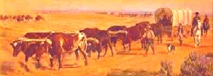
The California Trail carried over 250,000 gold-seekers and farmers to the gold fields and rich farmlands of the Golden State during the 1840s and 1850s, the greatest mass migration in American history. The general route began at various jumping off points along the Missouri River and stretched to various points in CaliforniaOregon, and the SierraNevada. The specific route that emigrants and forty-niners used depended on their starting point in Missouri, their final destination in California, the condition of their wagons and livestock, and yearly changes in water and forage along the different routes. The trail passes through the states of MissouriKansasNebraskaColoradoWyomingIdaho,UtahNevadaOregon, and California.

Before the trail was blazed, the Great Basin region had only been partially explored during the days of Spanish and Mexican rule. However, that changed in 1832 when Benjamin Bonneville, a United States Army officer, requested a leave of absence to pursue an expedition to the west. The expedition was financed by John Jacob Astor, a rival of the Hudson Bay company. While Bonneville was exploring the Snake River in Wyoming, he sent a party of men under Joseph Walker to explore the Great Salt Lake and find an overland route to California.
Early settlers began to use the trail in the 1840's, the first of which was John Bidwell, who led the 1841 Bidwell-Bartleson Party. In 1842, a member of the Bidwell-Bartleson Party returned to Missouri on the Humboldt River Route. Among them was a man named Joseph Chiles, who would lead another party to California in 1843 and play an important part in the subsequent opening of more segments of the California Trail. Throughout the 1840's settlers would develop short cuts on the route to California. One such short cut, called the Hastings Route, ran south of the main route. This "new" route would spell the death of many of those in the infamous Donner Party.
Donner Lake Encampment
Lithograph of Donner Party encampment at Donner Lake
 by C.W. Burton, courtesy California Digital Library.

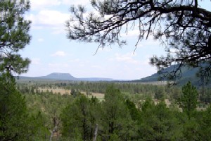
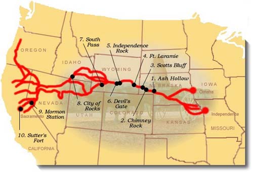
The main branch of the trail across the Great Plains generally followed the same path as the Oregon and Mormon Trails, but extended to California from various points in southern Wyoming and Idaho. The trail followed the Missouri River before crossing the great plains of Nebraska along the Platte and North Platte Rivers to present-day Wyoming. It then followed the Sweetwater River across Wyoming, then northwest along the Snake River to Fort Hall in present-day southeastern Idaho. Fort Hall was the Hudson Bay Company's post on the Snake River. From here, the primary route followed the Snake River south to American Falls, past Massacre Rocks, and Register Rock to cross the Raft River. After the crossing of the river, the trail split with theOregon Trail, with the California bound emigrants turning south through the Raft River Valley to the City of Rocks.The trail then climbed through the Pinnacle and Granite Passes, before dropping down to Goose Creek and meandering south through the northwest corner of Utah and into Nevada. At the headwaters of the Humboldt River in present-day northwesternNevada the California Trail followed the north bank of the Humboldt River southwest through present day Elko, Nevada and the narrow Carlin Canyon, where, during periods of high water, the route was almost impassable.
West of Carlin, the California Trail climbed Emigrant Pass, descending into Emigrant Canyon to rejoin the Humboldt River at Gravelly Ford. Here, the route divided to follow the north and south sides of the river, before rejoining at Humboldt Bar. Various routes branched out across the Sierra Nevada, as the emigrants made there way to various destinations in California.

Early emigrants once called the California Trail an elephant, due to the difficult journey. If you wanted to get to California in pre-railroad times, you were guaranteed an arduous trek. California emigrants faced the greatest challenges of all the pioneer emigrants of the mid-19th century. In addition to the Rockies, these emigrants faced the barren deserts of Nevada and the imposing SierraNevada Range.

The travelers of the California Trail often quipped that if you had "seen the elephant," then you had hit some hard traveling.

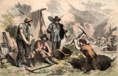
When gold was discovered at Sutter's Mill in Coloma, California, the trickle of emigrants became a flood as thousands of prospectors and families made their way to the Golden State in hopes of finding their fortunes. According to some statistics, over 70,000 emigrants used the California Trail in 1849 and 1850 alone.

In the two decades of the 1840's and 1850's, the California Trailcarried over 250,000 gold-seekers and farmers to the state's gold fields and rich farmlands. It was the greatest mass migration in American history.

Eventually, the portions of the railroad followed parts of the California Trail and as the automobile was introduced and began to be used by the masses, highways replaced the trail. Today, U.S. Highways 40 and 80 follow the path of the California Trail.

The California Trail system, which now includes approximately 5,665 miles of trails, was developed over a period of years. Numerous cutoffs and alternate routes were tried along theCalifornia Trail to see which was the "best" in terms of terrain, length and sufficient water and grass for livestock.

City of Rock in southern Idaho
City of Rocks in southern Idaho courtesy
National Park Service


California Trail in Nevada, approaching the Sierra Nevada
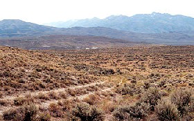
California Trail in Nevada, approaching the Sierra
Nevada, courtesy National Park Service.


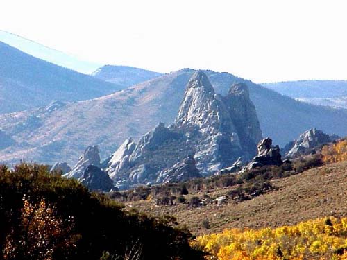
Today, more than 1,000 miles of trail ruts and traces can still be seen in the vast undeveloped lands between Casper, Wyoming and the West Coast, reminders of the sacrifices, struggles, and triumphs of early American travelers and settlers. About 2,171 miles of this system cross public lands, where most of the physical evidence that still exists today is located, including the names of emigrants written with axle grease on the rocks at theCity of Rocks National Reserve in southern IdahoMore than 300 historic sites along the trail will eventually be available for public use and interpretation.
© Kathy Weiser/Legends of America, updated June, 2010.

Cute video watch it !

GoAnimate.com: wealth 4 all dinner by mrhall909

Like it? Create your own at GoAnimate.com. It's free and fun!